Trail Walking Le Gua - L'Eperrimont  ou l'Indien en mode hivernal - Photo

L'Eperrimont ou l'Indien en mode hivernal

 patjobou
patjobou

User

© OpenStreetMap contributors
Length
Length
7.4 km
Max alt
Max alt
1406 m
Uphill gradient
Uphill gradient
469 m
Km-Effort
Km-Effort  
13.6 km
Min alt
Min alt
965 m
Downhill gradient
Downhill gradient
471 m
Boucle
Boucle
Yes
Creation date :
2021-03-18 08:40:19.423
Updated on :
2021-03-18 17:52:41.723

(0 Reviews)

Walking
Walking
3h09
Difficulty : Difficult

Scan this QR Code to open this trail in the SityTrail application

FREE GPS app for hiking

Logo SityTrail SityTrail

IGN / Geographical institutes

Download SityTrail from the App Store Download SityTrail from Google Play

Logo SityTrail SityTrail World

The world is yours!

Download SityTrail from the App Store Download SityTrail from Google Play Download SityTrail on Huawei AppGallery

About

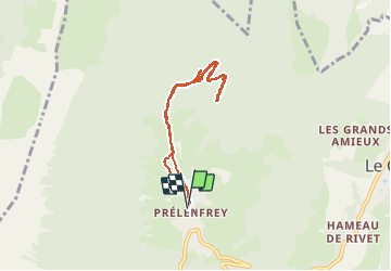
Trail Walking of 7.4 km to be discovered at Auvergne-Rhône-Alpes, Isère, Le Gua. This trail is proposed by patjobou.

Description

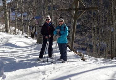
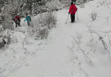
Surprise à l'Eperrimont un 18 Mars: 60 cm de poudreuse, qui nous feront 'brasser' un maximum de neige pour arriver au sommet.
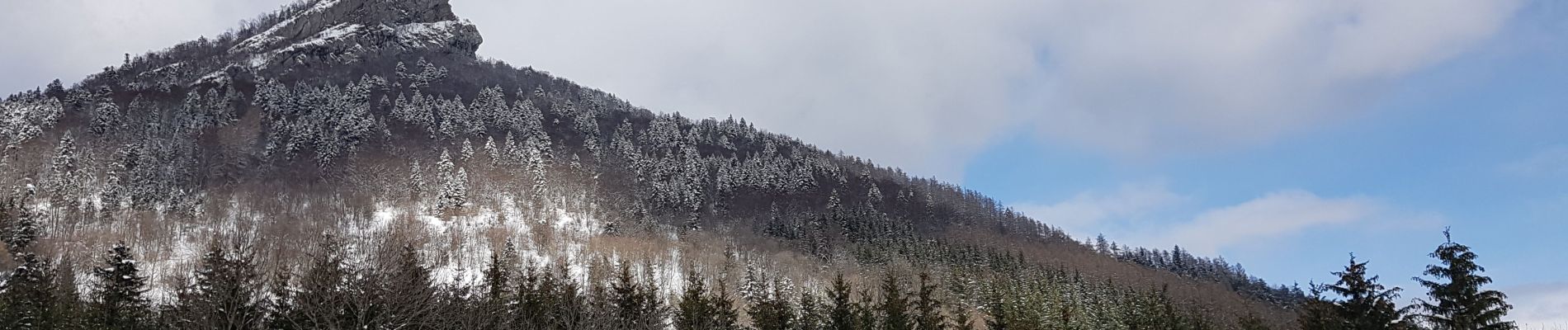
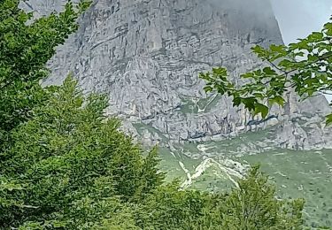
Ce sommet est également surnommé l'Indien, à cause de son profil particulier.
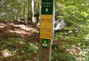
Juste après le col de l'Eperimont, ne pas se laisser tenter par une nouvelle piste qui redescend vers St Paul de Varce, bien continuer à monter par l'ancien tracé qui part sur la droite au dessus d'un éboulis, sous la neige bien sûr. Voir notre demi tour sur la trace (à 2,4km).
Quand à trouver le départ du sentier écologique sous la neige, c'est un rêve ! Déjà l'été, il n'est pas facile à trouver ....
Un beau sommet méconnu, proche de Grenoble.

Elevation profile

Photos

Positioning

Country:
France
Region :
Auvergne-Rhône-Alpes
Department/Province :
Isère
Municipality :
Le Gua
Location:
Unknown
Start:(UTM)
705893 ; 4988186 (31T) N.

Trails nearby

Trail Walking Villard-de-Lans - villard col des 2 soeurs - Photo
Walking
arnaudconde

Walking

Medium
(1)
Villard-de-Lans, Auvergne-Rhône-Alpes, Isère, France
7.7 km | 13.8 km-effort
2h 45min
Yes
Trail Walking Château-Bernard - la soldanelle - Photo
Walking
cmarit

Walking

Easy
(1)
Château-Bernard, Auvergne-Rhône-Alpes, Isère, France
6.1 km | 10.8 km-effort
3h 17min
No
Trail Walking Villard-de-Lans - Le sentier Peronnard et le Pas de l'OEille - Photo
Walking
tracegps

Walking

Easy
(1)
Villard-de-Lans, Auvergne-Rhône-Alpes, Isère, France
13.7 km | 25 km-effort
6h 0min
Yes
Trail Walking Villard-de-Lans - col_vert - Photo
Walking
vrolanta

Walking

Medium
(2)
Villard-de-Lans, Auvergne-Rhône-Alpes, Isère, France
8.7 km | 16.4 km-effort
3h 0min
Yes
Trail Walking Vif - la ferme oriol en circuit  - Photo
Walking
Youcef Atallah

Walking

Very difficult
Vif, Auvergne-Rhône-Alpes, Isère, France
13.7 km | 24 km-effort
3h 15min
Yes
Trail Walking Château-Bernard - tête des chaudières et rocher de la Balme  - Photo
Walking
paulin bruno

Walking

Medium
Château-Bernard, Auvergne-Rhône-Alpes, Isère, France
19.2 km | 36 km-effort
7h 22min
Yes
Trail Walking Château-Bernard - sous pas Balme de Arzelier - Photo
Walking
Ninie38MD

Walking

Medium
Château-Bernard, Auvergne-Rhône-Alpes, Isère, France
12.5 km | 21 km-effort
6h 11min
Yes
Trail Snowshoes Villard-de-Lans - de l'eau - Photo
Snowshoes
ferk

Snowshoes

Very easy
Villard-de-Lans, Auvergne-Rhône-Alpes, Isère, France
9.4 km | 15.2 km-effort
4h 14min
Yes
Trail Walking Villard-de-Lans - Le lac du clos du prey - Photo
Walking
GUIDE
nadinebondoux

Walking

Medium
Villard-de-Lans, Auvergne-Rhône-Alpes, Isère, France
11.7 km | 18.7 km-effort
3h 47min
Yes


Close
My subscriptions